Hiking With Gadget Girl
It's All About The Adventure!
April 2016 Journal Entries:
April 1, 2016 - Short Day
Distance: 9 miles
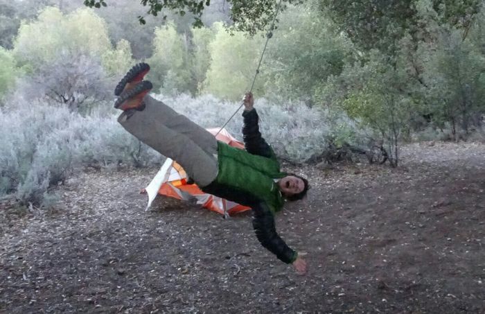
It was a chilly night with the wind blowing through the campground. Before we left, we just had to try the swing that was in the middle of our campsite. It's been awhile since I've been on a swing and it was great fun.
We had to hike the 6/10th of a mile back to the PCT to continue our trek northward. It was a steady climb pretty much of our day. The terrain hasn't varied much so we didn't take many pictures. We had a surprise visit from the USFS person who was doing a survey regarding our trip. He asked us to answer honestly and proceeded to ask us if we had started our trip on our selected day, if we had our PCT permits and CA fire permits, if we were thru hikers or section hikers, and if we were traveling together. The PCTA wants to know if people are honoring their start dates. They will be out in force gathering this information for the first 100 miles. He mentioned that he and his wife had thru hiked the trail in 2013 and of course we asked for his trail name. He doesn't have one but his first name is Jules. He said he lost 35 pounds over the course of the trip and his wife didn't lose any. Jules also has a tattoo of the Pacific Crest Trail on his left leg. I took a picture of it, it was so cool.Our resupply guy showed up closer than we anticipated with our first resupply of the trip and we were treated to Mike's Hard Lemonade while we resupplied our packs (food, different gear, etc). By the time we finished visiting and packed up our backpacks, it was much later than expected. We said our goodbyes and continued on until Burnt Rancheria campground. The campground is closed but Jules said they will not ticket PCT-ers if you want to simply camp overnight. It was a short hiking day, but I think it will be good for us so we don't overdo it. Our resupply guy Dave (who is in Lake Morena until Sunday) said that it looked like people were having trouble on the trail yesterday as helicopters kept arriving and taking people out. We haven't verified the story yet, so if you are a PCT hiker getting ready to start the trail, travel light (even slack pack the first day), carry enough water, and don't overdo it. It's supposed to get really warm over the next few days.
Our feet are doing well, no blisters yet (yay), we have been super lucky with the weather, cool winds, not too hot. When the wind does stop blowing, it warms up quickly. Didn't see very many critters today - a few lizards, ground squirrels, and a red headed woodpecker.
April 2, 2016 - Just north of Pioneer Mail
Distance: 14.4 miles
Woke up to 35 degrees, clear and cold. We set our goal for a 17 miler today, and decided to stroll thru Mt Laguna and check out the area. Came out of the campground and there was a cafe! Oooh, a second cup of coffee sounded so good. Went inside and with our coffee we had a second breakfast. Afterwards we continued down the road and ran across the Laguna Mt Supply store. Wow, we were like kids in a candy store! All the cool backpacks, tents, cooking gear, everything one needs for a thru hike. The place was packed to the gills with goodies. It was hard to leave the store. Finally moving on, trying to remind ourselves that we had 17 miles to go, we missed the first cutoff back to the PCT but found the second one. It was like a freeway, not with backpackers but with runners. Found a gorgeous huge pine cone that we would have loved to take home but we made do with pictures instead. Ran into a local who entertained us for a bit with a variety of things, but I was anxious to move on as all the coffee was going through. There was a lot more variety to the terrain today, long downhill into a day use area where we stopped for lunch. All of a sudden there were four drones buzzing around and a bunch of crotch rockets (motorcycles) zooming up and down the Sunset Highway. Finally asked one fellow what they were doing and and he said they were shooting a promo video on the bikes. Of course I had to get some pics for my hubby and then one of the video guys called out to stop production because an 'extra' was in the shot. That was me!
On we went trying to pick up miles and the day started getting warmer. We stopped at the Laguna Mountain Recreation Area, which is a huge mountain biking area and pumped water and filled all our water bottles. I also poured a bottle of water over my hair and rinsed the sweat and dust out of it. The wind made a great hairdryer. A few more miles down the trail and then we stopped at Pioneer Mail to look at the water supply but we passed on it. It was kind of gross looking.

A fellow resupplying his brothers gave Linda a big bottle of water so we were set with the amount we had to dry camp. Found a place to camp a few miles north among the big rocks. Not enough room to set up two tents, so Linda set up hers and I set up my bivy for the night. Met a few other gals, Ladybug and Full Rabbit, but the third didn't have a trail name. Didn't run into many critters again. Just drones....
April 3, 2016 - Rodriguez Spur Fire Tank
Distance: 13 miles
We had a lovely night under our rock with Linda in her tent and I in my bivy. The sunrise was beautiful. We stopped at the Sunrise Trailhead and filled up our water bottles. First we had to turn on the big tank to get the water to flow to the horse trough.

At the horse trough we then had to turn on another faucet which shot the water our horizontally across the trough. We had to put our bottles into the green colored water to catch the clean water. Afterwards, we chemically treated and Squeeze filtered our water. Don't want to get sick. As the day progressed it got hotter and hotter. We stopped for lunch at an abandoned water tank and then as we continued north, a lovely couple on a day hike insisted we take some of their water as they were on their way back to their car. The wife offered cookies which Linda graciously accepted. We headed down in elevation and a large gray snake slithered across the trail scaring the daylights out of me. Up a steep long dirt road to reconnect back to the PCT and more downhill. We could hear some shooting going on which sounded like very large guns. We had one mile to go and we were chatting away when all of a sudden, Linda stops talking and I hear a thunk. I turn around and there she was lying motionless on the ground. I rushed over to her asking if she was okay. There was a temporary lull before she answered me (yes, she was okay) in that lull I had horrible thoughts about stray bullets hitting her. But everything was fine, just dirty from crashing on the ground.
Arrived at the Rodriguez Spur Fire Tank which has delicious, cold water (filtered everything of course), rinsed the hair, and decided to spend the night there. Ladybug and her two buddies were there. Ladybug had a terrible time with the heat today and decided she was done with the trail and caught a ride with a day hiker.
Full Rabbit said that people are falling like flies off the trail due to injuries, blisters, and heat exhaustion. Linda and I haven't seen many other thru hikers at all and have been wondering where they are.
Got cell service (was the only one who had ATT service) and made plans for Dave to meet up with us tomorrow and get water and change out some gear.
April 4, 2016 - Hot Day
Distance: 11 miles
Got up extra early and made the time to wash our socks and undies before heading out for the day's hike. Met Steve who arrived at 7:30pm last night and had a nice visit. Today's hike was amazing. The cacti are flowering everywhere. We had to stop so many times to take pictures. We did have a goal to meet Dave at the highway at noon so we hoofed the last few miles quickly. We ran into a local who was walking up to meet Steve. What an interesting guy. He was picking up Steve and taking him back to his house and then he was driving "his bride" and Steve to Barrel Spring where they were going to hike back to Scissors Crossing. Linda thought it was mighty brave of him to send his bride off with another man for backpacking. He said they are old and will be too tired for any hanky panky!

We arrived at the highway (by the way there is a small cache of gallon jugs there) and continued walking the trail parallel to the highway and then we saw the drone zipping to us. We knew Dave was there! We drove into Julian for lunch and to get our free apple pie slice from Mom's (you have to show them your PCT Permit and ID). We were quite surprised to see how busy the town was and realized it was a tourist town. There are many "dessert" cafes featuring apples pies. We had lunch at one cafe that had outdoor seating so we wouldn't smell up the place (plus Dave brought our dog Bella). They were generous to let us use a wall outlet to charge our phones. Afterwards we found a park and did a quick revamping of our packs. Linda wanted her lighter sleeping bag and bivy. We both ditched our tents and will bivy for the next two nights. Then back to the main road for ice cream.
Dave dropped us back at the trail at 4pm and we discovered quickly how hot it still was (82 degrees). We found the underpass where some wonderful trail angel had set up brand new sand chairs (tags still on them) and a cooler that has an assortment of pop. Two other hikers swung thru but we waited until 5pm before heading out. We crossed the highway, started back on the trail and was instantly blown away at all the different cacti blooming. Some I've never seen before. Back to taking pictures!

It made the two mile uphill much more pleasant. Found a nice little sandy canyon to make home for the night.
We are having such a great time. Feet are still doing fine, but the days are getting hotter. We try to stop every two hours and take the socks and shoes off and dry them off. They are usually soaked with sweat. Yep, they are pretty stinky!
April 5, 2016 - North of 3rd Gate
Distance: 15.1 miles
We planned on getting up at 5am and hitting the trail early. We both overslept our alarms and I woke up at 5:30am. As we were packing up, a fellow hiker missed the turn on the trail and finally realized his mistake when he saw it dead ended. At 5:30am it is still dark and he and the other hikers were wearing headlamps to hike the trail. There were quite a few of them heading out early.
We finally hit the trail at 6:40am (yay, early for us) and hiked for six miles until we came upon the 3rd Gate. 3rd Gate is a well established water cache and there were pallets of one gallon water jugs waiting for thirsty hikers. There is a limit of 3 liters per person. The cache itself was about 3/10ths of a mile off the trail, all downhill.

Once we retrieved our water, had lunch, we decided to stick around for awhile to wait out the heat of the day. A handful of other hikers did the same thing. At 3pm we headed out. It had cooled down a little bit but was still very hot and I was drenched in sweat. Just before the last quarter mile to our campsite, Linda jumped back a bit and said we were going to have to wait awhile as there was a rattlesnake curled up and poised to strike.

We looked around but there was no way around the darn thing. I started tossing pebbles at it and after much rattling and hissing, it slithered off the trail. It was still mad at us as we hurried past him. Arrived at camp after a 15.1 mile day, cleaned up, ate dinner, and went to bed.

April 6, 2016 - Warner Springs
Distance: 15 miles
We were in our bivys and ready for sleep when a thru hiker came in with music blaring. We were glad he decided to try another spot rather than bother us with the music. Beautiful sunset this evening with clouds rolling in. We hear thru the trail-vine that the weather will be changing with rain and cold temperatures. But for today, we would luck out with a sunny but high overcast and windy day. The hiking was very easy all the way to Warner Springs. We met two southbound section hikers who called themselves Faithful and Grateful. Grateful had a terrible pancreatitis last year, spent two months in the hospital fighting for his life, and to have a couple more surgeries with the last one six weeks ago. We were amazed to see him on the trail. Congratulations to Grateful for beating the odds! Faithful said that we were the first "seasoned women" they had run across so far. We thought that was a delightful way to put it. We are definitely on the older side of it as most of these thru hikers are in the 20's. There are a few hikers in their 60's and a couple more in their 70's, but it mostly a much younger crowd.
We stopped at the 100 mile mark and celebrated our first 100 miles of the trail. Whoohoo! Stopped and got water at Barrel Springs and continued through rolling hills and open plains in very windy conditions to Eagle Rock. We did stop and soak our feet in the San Yistro Creek, the first flowing water so far this trip . After seeing pictures from past thru hikers, it was very exciting to see Eagle Rock in person. After Eagle Rock we had three more miles until we reached Warner Springs. At the last half mile, it was a pleasure to see my husband and dog greet us on the trail. At the Resource Center, we did our three day resupply in the parking lot. Because of the incoming weather we had to include our tents and raingear in our packs too. We have been very spoiled having Dave close by to switch out gear. Our feet thank him! Dave was awesome and also brought us green salads and cranberry juice.
We talked to a few thru hikers and one gal's feet were pretty messed up. Blisters all over, oh so ugly. She had been told that because she was new to hiking, she needed boots. She is not sure what she going to do as one blister on her toe looked infected. We felt bad for her.
We decided to stay overnight at the Resource Center because camping was free, there were bathrooms, and electrical outlets to plug all our gadgets in. What was unexpected was the rowdy group with the cussing and smoking. Apparently the sheriff came calling the night before because drinking is not allowed on school grounds and there was a group doing that very thing.
Oh, there is the cutest family of bunnies living under the bathrooms. They are adorable!
Linda now has a trailname! Seasoned Strider. I will probably call her SS for short.
That's it for now, I probably forgot a bunch of stuff, but I try to get the big stuff that happened each day recorded.
April 7, 2016 - Mike Herrera's place
Distance: 18 miles
We left Warner Springs at 7am after a final charge on the phones. The trail was lovely to walk on and wound us through Agua Caliente Creek, which was just beautiful. We crossed the creek numerous times, cautiously avoiding the abundant poison oak throughout the area. Someone even put a little sign up showing what poison oak looks like. We leapfrogged with Special Delivery all day. In the afternoon we had a rainstorm that was strong enough to require raincoats in addition to our umbrellas. We entered a State Park and gawked at all the beautiful flowering bushes and cacti. We are so glad we started our thru hike early so we could see the desert in bloom.
At the last 1/2 mile, we came across a colorful sign pointing the way to Mike Herrera's place. We knew we could get water there so down we went to the water tanks. Another sign stated that the place was open and for us to come on down and rest our weary soles. So we did, and what a surprise that was in store for us! Caretaker Josh greeted us and said pizza would be out shortly and to find a spot, put down the packs and make ourselves at home. There were quite a few other thru hikers there already, some had stayed more than one night. Josh made the pizza dough from scratch and cooked the pizzas in an outside oven. Incredibly good pizza for hungry hikers! We found a spot on the back porch and set up our tents for the night. More pizza arrived which we scarfed down. Ran into Mission Intervention who I was hoping to see because she is also from Hood River and her cousin is from White Salmon, which is just across the river from Hood River. Had a nice long visit with Prince and his lovely ukulele Ingrid. He was a musician in the Air Force Band for many years and had just left the military back in July 2015. He was assigned his trailname when he played his first song of Purple Rain.
It rained pretty hard that night and although we were glad to be on the porch and out of the rain, our tents still got wet due to the holes in the roof of the porch.
April 8, 2016 - Nance Canyon
Distance: 17 miles
As we were leaving Mike Herrera's place in full raingear and umbrellas at 8am, caretaker Josh popped his head out of the outdoor kitchen and said pizzas were coming out of the oven now and wouldn't we like another slice? We laughed, thanked him, and stated we needed to get on our way. It would have been so easy to stay a few more hours and not start hiking in the rain. But who knows? It may rain all day and we'd never get out of there. It did rain until 10:30am, pretty hard at times, but Seasoned Strider was in her Helium II jacket and ZPacks rain skirt, and I was in my full ZPacks jacket (almost to the knees), complete with umbrellas. After 10:30, we stayed ahead of the rain showers until about 2:30pm. We stopped at Tule Springs to get water and there was a hose attached to a spigot where we looked at the ugly urine-colored water coming out and almost didn't fill our water vessels. Because it was the only water for miles around, we did fill up and clamored back up the hill to our packs. Prince had caught up with us and he was almost out of water so he was forced to fill up all his water bottles and jugs. The afternoon storm finally hit complete with wind, and back on goes the raingear. We arrived at where we thought we would be spending the night but it was pretty windy. We were also surprised to see a wonderful water cache (with gallon jugs of water). We dumped our Tule Springs water and refilled with refreshing, clear water supplied by local trail angels. After reviewing the maps, we discovered we were only a mile away from Nance Canyon. We had already put in 16 miles, what the heck, what's another mile? We started climbing up and arrived at Nance Canyon where a handful of other thru hikers had already pitched tents. There wasn't much room left, but we found two spots for our tents. Full Rabbit was there whom we hadn't seen since the Rodriguez Spur Fire Tank, and she already had a fire going. Full Rabbit sure likes having a campfire! Seasoned Strider and I made and ate dinner while we listened to Prince play his ukulele and sing along with one of the other gal hikers who was a great singer. It was quite enjoyable!
April 9, 2016 - Ready for a zero
Distance: 7 miles
Didn't sleep too well last night. Because of the rain yesterday afternoon, everything was pretty wet and I ended up with a lot of condensation in my shelter (Skyscape X). I woke up with water dripping on me and on my quilt. The morning was pretty clear and if we had had the time, I would have draped gear over rocks for the sun to dry off. But we were eager to get going as we were finally going to take a zero day (okay, two zero days), get cleaned up, and get some resting in. Only seven more miles until we were picked up by Dave. About a mile from our campsite we came across trail angel Mary's welcoming water cache, free library, picnic tables, and a surf board for thru hiker's signatures. If we had known this was here, we would have hiked one more mile and planted ourselves here for the night instead of Nance Canyon. We signed the surf board with our trail names. We also saw the 150 trail mile marker, whoohoo! About five miles into the day, we saw a nice uphill trail on the mountain ahead of us and we hoped against hope that we wouldn't have to go up it. Alas, that trail was our last mile before Highway 74. Sure enough, there was Dave and Bella walking towards us. What a treat to see! We headed to the Paradise Cafe for lunch and ran into the younger crowd who had finished a couple of hours ahead of us. We just missed the breakfast menu, but the lunch menu was very good. After lunch, Dave drove us to Idyllwild where he was parked in the Thousand Trails (TT) campground for two weeks. The TT campground is way up at the 6,000 ft level and very cold and foggy. We heard reports of new snow with this incoming storm system on Fuller Ridge so decided to take two zero days and see how the weather was for a Tuesday relaunch. We're pretty sure there will be quite a bit of new snow up on the trail so we do have a backup plan in case we have to turn around due to poor conditions.
April 10, 2016 - First Zero Day in Idyllwild
Distance: 0
Our first zero day in Idyllwild was filled with the usual busy stuff. We prepared our two upcoming resupplies, did laundry, worked on routing and navigation, and then tried to guess what's going to happen when we hit the trail on Tuesday. The weather today was cold, wet, and dreary, and it started dumping rain about 4:30pm. There is new snow up above Fuller Ridge and will continue through Monday. Many thru hikers are here in Idyllwild, mostly I suspect at hotels. I sure wouldn't want to be trapped in a tent in a campground tonight. We went out to dinner at a nice restaurant which had great food. Afterwards, we took a quick trip up to Humber Park where the trail to the Devil's Slide connects to the PCT in 2.5 miles. That will be our access back to the PCT. On our way back down, a group of deer was standing off to the side of the road, frozen to the spot while I snapped a few pics.
Tomorrow we will try to visit the local ranger station to see if they have an update on what's happening up there and how much snow we should expect to run into.
April 11, 2016 - Second Zero Day
Distance: 0
Stopped in at the local ranger station to find out the status of Fuller Ridge and how much snow had accumulated up there from the recent storm. The nice ranger behind the desk said that that portion was outside their jurisdiction and gave us another ranger station's (at the 8,700 ft level) phone number. When I called that number, another nice ranger answered the phone and when I said that there was a wild rumor running around Idyllwild that there was two feet of new snow up there, he couldn't contain himself and laughed pretty hard. No new snow, just slippery, and we only needed to carry microspikes. All right then, tomorrow we start at Devil's Slide, go up approx 1,600 ft in 2.5 miles to the PCT and start heading north.
It was nice to have a two day break, especially with the weather being so yucky.
April 12, 2016 - Tackling Fuller Ridge
Distance: 16.2 miles
After a two day rest we were ready to hit the trail under blue sunny skies. Dave dropped us off at the Devil's Slide trailhead in Humber Park. It was quite chilly with the temperature at 34 degrees. Being in trail runner's with lots of mesh, our toes were quite cold. After about thirty minutes, I could feel tingling as my toes came back to life. I don't typically wear a long sleeve merino shirt, but it was cold all day and I kept that shirt on most of the day. The Devil's Slide trail is about a 1,600 foot elevation gain over 2.5 miles and we could tell that it was a very popular trail. We arrived at Saddle Junction and continued hiking upward under blue skies. We finally arrived at our first patch of snow and after starting on it, we realized it would be better if we put on our microspikes. A few thru hikers passed us, and we had a short visit with Sparks who was a section hiker. Once we reached the top, off came the spikes, and we had a beautiful long downhill until we switched over again to the north side. This section of snow was a bit more challenging and we were very thankful we had our spikes. Very slippery and icy in places. We used our GPS apps to navigate through this section and through the Fuller Ridge section. There was one area where someone has written a big 'NO' in the snow with an arrow pointing toward a big fallen log. There were many footsteps going towards to 'NO' sign, but Seasoned Strider went to see what the arrow pointed to, and after climbing over the tree debris, found the real trail. Taking no chances, we verified it with our GPS apps. Then lost some elevation and then the snow, but the low clouds had moved in and it became quite chilly. The last section of snow was over Fuller Ridge. It was slippery and icy, tracks were everywhere, so we used GPS to stay on course until we reached the Fuller Ridge campground. We were pretty whipped at this point, but we were still in the cold clouds, there was a strong breeze blowing, and the ground was really wet. We reviewed our options and at 5:30pm, decided to descend almost another 1,000 ft in 2.5 miles and find the campsite listed on GutHook's app. Once we left the Fuller Ridge campground and followed the trail to the west, we had wonderful sunshine the rest of the way to our campsite. Once we arrived, we met Monkey Bars and Triscuit, who had already made camp. They had heard conflicting reports about the trail we just finished so they decided to do the alternate route of the Black Mountain instead. They had also talked to one of the hikers who had passed us on the trail and he told them he had a terrible time and had fallen like 20 times, even with spikes on. I am thankful that we have years of experience spike hiking around Mt Hood. At times, it was fun to simply slide on the snow like skiing. I also have to say that the ranger I talked to yesterday was spot on with his response to me. No two feet of new snow, simply old slippery, icy, and sometimes mash potatoes snow.
April 13, 2016 - Long elevation drop
Distance: 16.5 miles
We didn't get up super early, because today was all downhill. How hard could that be? We did get on the trail at 7:30ish. It was mind boggling when we switched from alpine type of terrain to the abrupt desert. During the day, we descended 5,476 feet over 12.9 miles. The last 3.6 miles was a slight downhill and then flat. We had decided not to bring our umbrellas and I for one, sincerely regretted that decision once the sun hit about 11am. The top part was quite lovely, saw my first Horny Toad, and an amazing moth that hovered like a hummingbird over a purple thistle, and a new cactus bloom that I haven't seen before. The middle section of this huge downhill took all of our concentration so we didn't fall. Thorny bushes had overgrown the trail and there were a lot of sections that had washouts. The lower half had been recently worked on (thank you volunteer crews!) and after the middle section were a dream to hike on. The trail seemed to go on forever. Every time we stopped to check the GPS, we thought we had gone miles, and we'd only gone two. Ugh. We met another thru hiker called Cups and leapfrogged with her all the way to the Snow faucet. The winds kicked up and we were pushed around by some powerful gusts. The wind did help push the heat away from us so we were thankful for that. Once we reached Snow faucet, I called our resupply guy and found out he was already waiting for us under the overpass. Well, we still had 3.6 miles to go. Dave offered to fetch us so we didn't have to do the road walk, but we felt that was cheating, so off we went down the road. After about 3/4 of a mile, we found the PCT tread again and continued marching forward, struggling against the wind at times. I called Dave again to let him know that we were getting close and then Dave realized that he wasn't where we were going to show up at Hwy 10. We arrived at the railroad crossing and I climbed up the bank so I could see the freeway sign, snapped a pic, and texted it to Dave. We were at exit 110 and he was at exit 103. Somehow the maps he was looking at showed us arriving at Cabazon, but we were following the PCT signs which dumped us out seven miles east of there. We finally connected, got picked up, and was treated to a lovely Burger King dinner. We came back to the motorhome in Idyllwild to spend the night and to clean up a few things. After two tough hiking days, one day in snow, and the other day in basically desert conditions, I have to admit that I am fairly sore and reckon that we will reduce our mileage for a day or so to recover. What an adventure!
April 14, 2016 - Nero Day
Distance: 4 miles
Nero days are almost a zero day, but one puts in a little effort to make a few miles that day. That is what today was. Got up around 6am but wasn't in a 'frantic, get on the trail' mode frame of mind. We spent some time working on getting the newest PCT Water Report printed for this new section and had some issues with connecting to our printer that we had brought along in the motorhome. Finally got it done and then spent a bit of time trying to figure out how to divide our six day resupply into two separate three day resupplies. It simply couldn't be done so we had to carry a full six day bag of food for this section.Speaking of this section, there is about an 18 mile section of the PCT that is closed due to the Lake Fire wildfire that happened last year. There is no alternate route around and one is forced to hitchhike around to Onyx Summit, which is at trail mile 252.1. Most of the thru hikers try to hitch where we finished the trail yesterday at Hwy 10. Some people are lucky and get a ride. Others plan ahead and schedule a ride with family or friends. Others, we found out today catch a ride from a woman who is offering to take hikers around from Ziggy and the Bear's place for a $ 100 a carload (fits four hikers and packs). Seven hikers paid her to take them all the way to Big Bear and they simply skipped this whole section. Our personal resupply guy drove us from Idyllwild to Onyx Summit which took about 1.5 hours. As we were getting out of the car in cold, windy, but sunny conditions, there was Slingblade preparing to resume the trail. We started about 20 minutes behind him. A mile or so from the trailhead there was a comfy sofa and a trail magic metal box sitting on the side of the trail. Of course we had to open it and was wowed by the goodies inside. We helped ourselves to some cookies and signed the PCT register (left my hiking card). Thank you Big Bear Hostel for a wonderful treat! Four miles later we arrived at the Arrestre Trail Camp where Slingblade had already made camp. There was a small spring running which made it awfully tempting to stop and make it a very short day. The next good campsite wasn't available for miles so we decided to plant ourselves here for the night. It feels like it is going to be a very cold night so fingers crossed that condensation doesn't build up in our tents overnight.
April 15, 2016 - Very Cold Day
Distance: 19 miles
We woke up to a 32 degree morning and we hoofed it out of there as quick as we could to get warm. As I finished breakfast, I picked up my wet bandana and it was frozen. Slingblade left before us (he's quick!). We found a spot of sunshine and spent a moment warming up. Went on our merry way down the trail, and then came to a dirt road. We could see the beautiful trail across the road and continued on. Saw a PCT N -> sign cut into a log so of course we were on the right track. Crossed over a bridge and then sort of dead-ended. We hunted for the trail, could see footprints everywhere, but things didn't look right. We looked at three different GPS apps and they all stated that we were off the trail by quite a bit. So we headed back to the road, and the GPS apps said we were supposed to take the road down, cross over a small seasonal stream, and continue on. We did so, and there was the trail. We came to the conclusion that we originally were on the old PCT trail and for some reason was rerouted down this road. The trail wound down near the creek again and then headed back up the ravine on the other side. Arriving at the top, we were greeted with a very cold wind blasting at us. It was a day of changing clothes trying to keep warm. It was sunny but very cold. We decided to try for the Caribou Creek campsite which would make it a 19 mile day. It was an easy trail today, just strong, cold wind all day. Just after lunch, lo and behold, there came Cups slackpacking to Hwy 18. Spent a few minutes visiting and waved goodbye as we crossed Hwy 18 to continue on and she waited for a trail angel to pick her up.We stopped at Doble Creek and there was a faucet with a sign stating it was nonpotable water only for horses. I took some water anyway. It took awhile as the water came out as a dribble. On we went, for another 3.4 miles, a lot of it uphill. Arriving at Caribou Creek, we had hoped it was tucked away from the wind but was dismayed to discover it was just as windy and cold. We quickly set up our tents, crawled inside, and tried to get warm. I actually cooked my split pea soup inside my tent as I didn't want to leave the warmth of my quilt.This wind is supposed to last for another day so we are looking forward to Sunday when it will have died down by then.
April 16, 2016 - Holcomb Creek
Distance: 17.4 miles
I wear ear plugs at night to keep night noises at bay, so I missed all the high wind action last night. It was 35 degrees at 5:45am and still freaking cold and windy. We packed up as quick as we could and headed out. Unfortunately we had an elevation climb that quickly brought pockets of snow patches here and there. We still had on our long underwear on with several layers on top to stay warm. That darn wind was biting cold. We popped over a ridge which temporarily blocked the wind, and there spread out before us was Big Bear Lake. We could see the ski resort on the other side of the lake. We were so happy to be on this side of the ridge but it didn't last long as the trail mosied back over the ridge and we were blasted again. We finally started losing elevation but the wind stayed with us most of the day. We ran into a trail angel by the name of Dean who gave us a banana and some water. He said he really enjoys helping the thru hiker's out each year and moves around on the back roads kind of following everybody around. He said don't be surprised if we run into him again on the trail. Pretty cool guy. By late afternoon the wind became more manageable and we were able to hike in shorts and T-shirt. We went through a beautiful little canyon and could hear Holcomb Creek below us. We arrived at a dirt road and saw some 4WD vehicles making their way down this knarly Jeep trail. It was fun to watch them. This place is full of dirtbikers and 4WD vehicles. They're everywhere. After another big mileage day (for us), we found a lovely campsite adjoining the creek. Soaked our feet, cleaned up a bit, made dinner, and hit the hay.
April 17, 2016 - Deep Creek Hot Springs
Distance: 15.7 miles
Lovely quiet night with no wind! Continued with the downhill where we ran into section hikers who were brothers - Fishy and Found It. They were hilarious to talk to. They warned about the upcoming Poodle Bush and described what it looked like. Found It asked where we were staying tonight and we said maybe Deep Creek Hot Springs or a couple of miles past that. They warned us about naked people there and Found It called it Sausage Soup. Beware of naked men showing all. We continued down the hill and came across the Deep Creek Bridge. This is where we ran into a lot of people out for a stroll. We took the short path to the parking lot where we expected to see Splinters Cabin. Well, it has been deconstructed a bit and made into a covered picnic area. You can see where the old fireplace used to be. The main reason we stopped here was to drop our garbage in the garbage cans. After lunch we continued on the trail which followed the Deep Creek for many miles. We stopped at the last seasonal creek just before Deep Creek Hot Springs and rinsed our hair out and soaked our feet in the wonderful cold water. Continuing on to Deep Creek Hot Springs, we wove in and out following the hillsides that had beautiful colorful flowers of purple, yellow, red, and white. We arrived at the hot springs and although we were warned about the amount of people (and naked people), we were taken back on how many teenagers there were. It must be spring break for California. I noticed a little pain on the left hand side of my back end late this afternoon and I must have pulled a little muscle somewhere. Took some Advil and am really hoping it will be gone in the morning.
April 18, 2016 - Long easy downhill to Hwy 173
Distance: 15 miles
We started off early this morning but not early enough to see a naked man walking down to the enclosed hot spring with his toiletry kit. I took a picture of him and luckily I just got a side and back view. No plans to post it anywhere, maybe just include it in my future PCT photo book.We were passed by three young thru hikers whipping down the trail. We haven't seen very many thru hikers lately. We mosied along enjoying the meandering Deep Creek below us. It was sad to see some tagging of rocks and such as we neared the end of the canyon. I deliberately went slow so I didn't antagonize that sore muscle in the back end. We came around a corner and there was the mighty Mojave Dam. It was so big and there wasn't any water for it to hold back. The trail took us down the side and parallel to it and then crossed over a shallow running creek. It was about calf deep so we took off our socks and shoes and waded across. Felt lovely on the feet, although we had to be careful of broken glass in the water. Filled up a liter of water as we weren't sure when the next water source would be. The trail continued weaving in and out of the hillsides with a view over the valley. It felt like it took forever to reach our 15 miles for the day. About 10 miles into it, I was in front and to the side of me I heard a rattlesnake. Because it came from the side and seemed a bit uphill, I took off running. That left the snake between me and Seasoned Strider (SS). Once I felt safe, I turned back and cautiously viewed the foilage on my side and SS searched for the snake on her side. She saw it curled up against the base of a tree about 12 feet off the side of the trail. She zipped past quickly while that snake rattled his tail vigorously.We have noticed an abundance of poison oak in the draws of each hillside in this section. It seems to cluster around water sources. In one draw, it was difficult to dodge it as it was growing into the path from both sides. Time will tell (3 days) if either one of us was tagged with poison oak.SS stopped suddenly on the trail and I thought it was another rattlesnake. Nope, just two horned lizards mating on the trail.Some of the seasonal streams are still running but most are not. At the last8/10th of a mile from Hwy 173 I was just about out of water, and lo and behind, some kind person left one gallon jug of water on the edge of the trail. I only took 1/2 a liter of water and drank it down. What a lifesaver, especially since it was quite hot. Finally arrived at Hwy 173 where Dave had just arrived to take us back to the motorhome for a zero day.
April 19,2016 - Zero Day
Distance: 0
Today passed quickly with the usual zero day chores - eating, rehydrating, washing clothes, refilling various tubes (like suntan lotion), and repacking the packs with resupplies. This next section will include a big 6,000 ft uphill, a 28 mile no water dry section, and the attempt to get over/around Mt Baden-Powell. We have to carry microspikes and potentially an ice ax. The weather looks like it might be changing for colder temps which could impact our forward progress. There is also a small detour we have to do for the endangered yellow legged frogs. What an interesting adventure!
April 20, 2016 - Windy, Sunny Day
Distance: 18 miles
Got up at 5:00am to prepare for the drive back to Hwy 173 to continue our hike. We had a mindset of doing 12 miles for the day but when we reached that target, it was only 1pm. Still plenty of the day left to hike. So we continued on. We rounded beautiful Silverwood Lake, which is a reservoir, oohed and aahed at the beautiful beaches, and then started the uphill trek to leave the valley. We stopped at the Silverwood Lake day area where there was potable water, drinking fountains, covered picnic area, and flushable toilets. Doesn't take too much to make us happy!After our morning break, we headed out against a head wind. We had our umbrellas out and a sudden gust caught SS's umbrella and turned it inside out. She struggled with the umbrella against the wind while I couldn't hold back my giggles. It was hilarious to watch. We tried to keep our umbrellas out but the wind kept building.We ran across another snake that had similar markings of a rattlesnake but didn't have a rattle. It was a nice long one. At first it didn't move, so SS tossed a few pebbles to no avail. Then she poked the snake with her pole. No response. So she stuck her pole under the snake and flipped it towards the side of the trail. A little more response from the snake as we saw its black tongue flicker in and out. One more toss of the hiking pole got the snake moving and it slithered away up the hill away from us. We reached the ridge just before lunchtime and started the long downhill. Stopped for lunch and shared shade with an Australian from Tasmania named Eric. He was fun to talk to, especially to listen to his accent. He was really looking forward to McDonald's which is at Interstate 15, as he said trying to resupply from local convenience stores doesn't provide many choices and he really wanted 'real food'.The rest of the afternoon was spent battling the wind on the long downhill and then on the final uphill that went around huge sand cliffs. We leapfrogged with Wild Turtle all day. We also met twin sisters from Denmark who had started from about Palm Springs area and are hiking the trail for eight weeks. They were moving slow as they had painful blisters all over their feet and toes. We felt so bad for them. Trail angel Dean felt so sorry for them, that a week or so back, he bought them new trail runners and also paid for a hotel room so they could tend to their foot issues. He's been monitoring them ever since.As we got closer to Interstate 15, we discovered a lack of camping options. This was a concern as we would not be able to go further than 18 miles today due to SS's feet issues. I sent out a text to Dave who was already in the vicinity, so he picked us up at Highway 15, just a hop, skip, and a jump from the popular McDonald's. After all this, we could have slack-packed today rather than carry four days of food, and 4 liters of water. Back at the motorhome, we showered and then reviewed our options for tomorrow. It looks like we will have a great option of slack-packing for 14 miles so we excited about that!
April 21, 2016 - Long Uphill, Sunny Day
Distance: 14.4 miles
Just because we were at Cajon Pass, we had to do McDonald's, so we had our second breakfast there. (Most thru hikers coming through here stop and eat multiple meals.) This put us at our trailhead much later than usual. We started out following the trail under the freeway and railroad underpasses. Another thru hiker was preparing his backpack for the day and we exchanged pleasantries. He mentioned that he been here for two days, simply eating most of the time. His goal was to make it to Wrightwood this evening. We started the uphill climb about 9:30am at the 2,991 elevation level and it would take us most of the day to go 14.4 miles with a 3,327 elevation gain. Again, the trail is mostly easy, but with the sun beating down on you and zapping your energy, it can be a tough climb. We slack-packed today for a couple of reasons - Seasoned Strider now has blisters on both feet and wasn't 100 percent sure she could hike the whole day, and because we could. Dave followed us all day, stopping at the 5 and 10 mile markers via back roads to check to see how we were doing. As long as we didn't stop, SS kept chipping away at it all day. The last two miles were the hardest for me. My energy was really low and then we finally got to see what Poodle Dog Bush (PDB) looks like. Ugly. Really ugly. We did our best squirming around trying not to touch any part of PDB as it is like poison oak but much worse. Finally arrived at our final designated spot for the day and Dave drove us back to the campground via the back roads which shaved off 20 miles from driving the freeway back. Decided to go out to dinner at Chili's - it was pretty tasty after a long day of hiking!When we were hiking late afternoon, Dave saw a thru hiker near our destination and saw that he was trying to use his poles as crutches. He stopped and asked how things were going and apparently they weren't going too well for this young man. He thought he could do 25 mile days and his foot started hurting, he ignored it, and now he couldn't put any pressure on it. Dave offered to drive him into Wrightwood which the hiker quickly accepted. The hiker bought Dave a six pack of beer and a hot dog for helping him out!
April 22, 2016 - Windy, Windy Day
Distance: 13.6 miles
Today I hiked solo as Seasoned Strider took a break to rest her feet. Dave dropped me off at 7:30am and off I went. The trail was night and day different from yesterday. No Poodle Dog Bush and no poison oak. The wind started blowing and continued to build throughout the day. The higher up I went, the colder it became. I came upon three hikers who I recognized as "the family", who I have been following on Postholer. It was great fun to meet them in person. By this time the wind was howling. I put on two jackets and continued hiking as fast I could to keep warm. I caught up with the Danish Twins at Guffy Campground. They were huddled against a fallen log wearing their down jackets. I didn't think anybody would believe me how hard it was blowing so I made a little video of the wind blowing. After Guffy Campground, the trail started downhill for most of the way to Hwy 2. I had planned on hiking to Vincent Gap but I knew that Dave and SS were waiting for me in Wrightwood, and by the time I reached Inspiration Point, I was ready to leave the trail and wind for the day. The Danish Twins decided to push on to Vincent Gap and decide what to do for camping when they arrived there. I totally admired their commitment to keep going. Everybody else was bailing to Wrightwood. After pickup, we returned to Wrightwood and to the cafe that kept Dave and SS entertained all day while I was hiking. I met Ranger and Skeeter and we had a short huddle to determine what to do about Baden-Powell. Reports that had come in all stated that the north side of the mountain was a sheet of ice and our microspikes were not up to the task of keeping us from sliding down the icy mountain. We decided to do the alternate trail in addition to the Endangered Species Detour. So we are now done with slack-packing this section and we will be backpacking for three days for 48 miles.
April 23, 2016 - Alternate Trail
Distance: 12.9 miles
Seasoned Strider was ready for hiking today. She swapped out shoes and hopes that using different shoes will help with the blister issues. One foot is looking great, the other one still has a bit of redness to it. Dave dropped us off at Inspiration Point where it was a chilly 37 degrees with a breeze blowing. We hiked the 4.7 miles down to Vincent Gap where normally one would start the ascent up Mt Baden-Powell. We had made the decision yesterday afternoon to do the alternate route, so we took the five mile trail to the South Fork Campground. There is a warning that this trail is not up to PCT standards and boy were they right. The first mile of so was nice - it did have washouts here and there, and then we could see the repair work that has been done over the years to help shore up the trail. We arrived at the South Fork campground and I simply needed a siesta to crank up my energy level. We found a shaded picnic table, unloaded, laid down on the bench and we both had a nice snooze. I think mine was longer than SS's nap. Feeling fairly refreshed from our nap, we continued another 3.2 miles to Holcomb Canyon Creek and set up for the night. It was a short day of 12.9 miles, but I sort of needed it.Tomorrow we continue the alternate route that melds into the Endangered Species Closure Detour. Four miles of the PCT has been closed for many years to protect the Mountain Yellow-Legged Frog which is now nearly extinct. Once we finish the Detour we will be back on the PCT.
April 24, 2016 - Alternate and Endangered Species Routes
Distance: 14.3 miles
It was quite cool in the morning but we quickly got going up the trail. This part of the trail has been shored up with a variety of materials. We arrived at a sign that showed the way we came from and an arrow to the Devil's Chair. Peering at the tiny lines on the alternate map, I was unsure if it was the alternate PCT route, but what the heck, let's go see if the Devil's Chair trail was our trail. It was a well traveled trail with reinforced bars along the way. Pretty soon there were railings to hold on to, and stepped angles to drop down on, and finally we were at a dead-end overlooking beautiful rock formations. Well, this wasn't the trail we wanted but there were sure a bunch of day hikers arriving to take in the view. Back we went to the trail sign, and beyond the tiny campsite was our trail. Not marked. On we went, running into many more day hikers. We were stopped a few times and people were astonished to find out we were hiking the Pacific Crest Trail from end to end. One gal who identified herself as Landslide Linda insisted she have her picture taken with us. We were happy to comply.
At our morning snacktime, here comes a fellow backpacker coming southbound, stops in front of us and asked if we were PCT hikers. He announced he had literally been lost the past two days. He had missed the South Fork Campground trailhead and had taken the dirt road that veered away from the trail. After wandering around lost, he ran into a fellow driving his vehicle on the back roads who rescued him and took him to town. He called his daughter who delivered him to a trailhead north of us and he still was going the wrong way (southbound). He asked if he could follow us to get back on track. We said sure! He then admitted he was inexperienced in the whole backpacking and navigation thing. His trailname is Driver.
After a nice four mile downhill, we spent a major portion of the afternoon going uphill to the saddle. The wind was whipping on the other side so we planted ourselves for our afternoon snack on the leeward side. Heading down the windy side, we finally arrived at the Burkhart Trail where there was a small campsite. It was cold and windy so after reviewing the maps, we continued on one more uphill mile to the Cooper Canyon campground where we ran into a handful of thru hikers already set up for the night. As I was cooking my evening meal, I talked to Little Spoon who had arrived and was deciding if she was going to continue on after her dinner or stay the night. She was quite interesting to talk to as she recently finished the AT and after she finished the PCT, was thinking about hitting trails abroad. Little Spoon was from Alaska and had hiked the Baden-Powell trail that very day, the one we diverted around. She said it was no big deal, that she only needed her microspikes two times. She even spent the night on top. Although it would have been nice to do the Baden-Powell route, we had a great time on the alternate route.
April 25, 2016 - Unexpected snowstorm
Distance: 23 miles
Woke up to cold and windy conditions, my little temperature gauge said 30 degrees. Water bottles weren't frozen though so maybe the gauge is off by a degree or so. I took off like a shot uphill trying to get warm, SS was a little surprised at the pace. It stayed cold and windy most of the day, which actually created really nice hiking conditions. We also found the 400 mile marker lined in stones. We stopped at 12:30pm and decided to unload our packs and dry out any possible condensation issues in tents and in sleeping bags. Looked like a garage sale had hit the side of the trail. The clouds started rolling in and it started getting colder. Our plan was to stop at about the 15 mile mark in order to leave about eight miles for the next day for pick up from Dave. At the 15 mile mark we ran into "the family", i.e. Spinner, Widowmaker, and Gandolf. The small campsite was very windy and had a lot of Poodle Dog Bush around. We decided to continue to the next campsite about 1.5 miles further, but once we arrived there, it was higher in elevation, colder, and windier. We had to make a go/no go decision on what to do. Then the snowstorm arrived! Well, that pretty much decided it, we headed down to the Lower Pacifico Campground hoping it was low enough in elevation to get out of the snow. We had to stop and put on our raingear as the wind was blowing the snow all around. When we arrived at the Lower Pacifico Campground, another thru hiker passed us stating he was heading for lower ground. After another sudden flurry of wind driven snow, it was obvious that we needed to do the same thing. Then a loud crack of thunder put the icing on the cake. Off we went downhill hiking as fast as we could. I had cell service and notified Dave that we were coming out that evening at the Mill Creek Fire Station. It wasn't our planned mileage for the day, but that's life in the thru hiking world. We found Driver already set up his tent off the side of the trail with Jacob (no trail name) just below him setting up for cowboy camping. So everybody on the mountain had headed down out of the storm. Unfortunately the long downhill caused a new blister to form on the ball of SS's foot. So 23 miles later, we arrived at the Mill Creek Fire Station, zoomed to the pit toilet, signed the register on the picnic table, and then found Dave in the lower picnic area.
Note: There is a lot of Poodle Dog Bush in this section. The latter part of the hike was much easier to avoid it as super volunteers had obviously just cleared the trail. It was beautiful to walk on.
We will be taking a few zero days due to some personal business we need to take care of. Back on the trail probably on Friday.
April 26, 2016 - 1st Zero Day
Miles: 0
The usual zero day activites - washing clothes, eating food, cleaning and repairing gear. Prepping for the next section...
April 27, 2016 - 2nd Zero Day
Miles: 0
Yep, the second of three consecutive zero days. Will be back on the trail on Friday....
April 28, 2016 - 3rd Zero Day
3rd and final zero day. Back on the trail tomorrow!
April 29, 2016 - Back on the Trail
Distance: 18 miles
We got a late start this morning and we started the long uphill about 10am. At about 2.5 miles, we came to the Poodle Dog Bush alternate trail, which actually was a 10 mile road walk. After dodging the PDB for the first few miles, we decided to take the alternate route so we didn't have to constantly worry about brushing up against that nasty PDB. It was a constant uphill walk. The road itself was closed (all the back forest roads have been closed due to fire danger) but we did see four fire support trucks drive up the road and later drive back down and out. Even on the sides of the road the PDB was thick. Part way through the day we came across the Station Fire 2009 Memorial. It was a sobering sight to see all the different caps stacked up on each side honoring two fallen firefighters. We continued on our way up the road sticking closer to the middle of the road. It felt like the uphill would never end, but we finally started the downhill to the Messenger Flats turnoff. When we arrived at the Messenger Flats Campground, big signs were posted that the campground was closed. But they had pit toilets and picnic tables so we headed down. As we were enjoying our afternoon snack, another thru hiker arrived. His trail name is Nuts. Nuts said he was having issues with his knee and shin so he couldn't go any further today. He started the trail on Apr 7th and hasn't taken a zero day yet. He is not sure if he will be able to finish the trail as he having such trouble with his aches and pains. We said goodbye and continued on for the final six miles to the North Fork Campground. The final two miles were tough as not only did we have to continually dodge the PDB, we also had to dodge the healthy and strong poison oak. It can be so mentally draining constantly watching out for both itchy plants. Finally arrived at the North Fork Campground and it was quite windy. It was a challenge for me to set up my shelter. I am having such a struggle with this SMD Skyscape X shelter. Inserting the pole tips into these little flaps to hold up the tent is a huge crashing pain. I much prefer my Lightheart Gear Cuben Fiber Solong 6 shelter. It's 10 oz heavier than the Skyscape X, but oh so easy to set up. I may simply give up on the Skyscape X and start carrying the Solong 6 instead starting at the next resupply.
April 30, 2016 - To Agua Dulce
Distance: 18 miles
Woke up with condensation in my shelter, plus it had drizzled rain a bit overnight so the outside was wet too. Toweled it off inside and out, packed it up, and headed down the trail. It was a beautiful downhill start to the day. We were quickly overtaken by four guy thru hikers; whew, they sure can hike fast. Just as we were coming into Soledad Canyon, we heard a "yoooouu-hooo" and sure enough there was Dave and Bella walking up the trail to meet us. We didn't expect them until Agua Dulce where they will deliver our four day resupply, so it was quite a treat to refill our water bottles with fresh water. We also took the time to unload our packs and dry out bags and tents while we ate our lunch. After we said our goodbyes, Dave left to go pick up some thru hikers walking the road who wanted a ride into Acton, and we headed north on the trail. Came across some railroad tracks with a passenger train passing by, so I gaily waved at the people staring out at me and no one waved back. Must have thought I was a hobo. Across the tracks was a PCT monument that was stating the completion of the trail in June 1993. Of course we had to take pictures of it. Upwards we went and ran across a noted "cave". Just a tiny side trail to a lovely opening in a rock face. Decided to have our afternoon snack there, and as I was sitting there minding my own business, I suddenly felt a smack against the back of my leg and then a frantic squirming and a dash away into the weeds. It happened so fast I didn't even have a chance to shriek. I looked down and discovered a quarter size hole just under my leg. I am assuming it was a lizard, not a snake! Back on the trail, we arrived at Interstate 14 and crossed under it in a very long tunnel. The most interesting thing about this tunnel is that it was shaped like the PCT emblem. Coincidence or designed that way? Anyway, when we reached the other side, it was like a whole other world. The Vasquez Rocks, where many movies and TV shows were filmed. It was fascinating. We did have to dodge a ton of poison oak throughout the lower canyon. The trail routed us around the entrance but we stopped and used their porta-pottie. Their porta-potties had real sinks, water (foot pump) and soap dispenser. Very cool. At the other end of the entrance we found Dave and Bella. Decided to treat ourselves to great pizza at the Big Mouth Pizza place in Agua Dulce for dinner. Most excellent pizza!